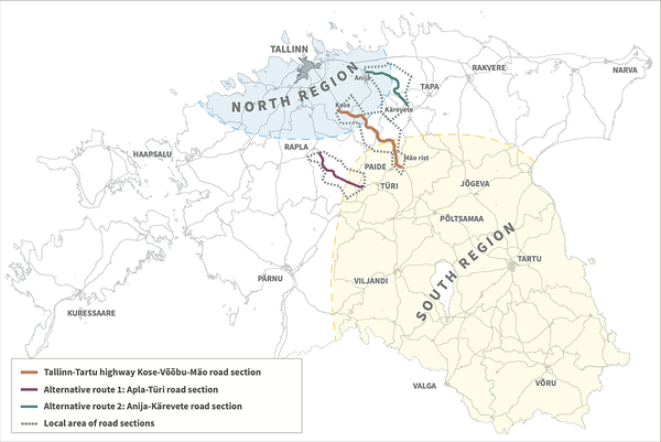
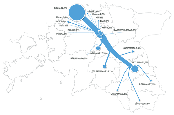
A road planning project for a new section in highway E263 in Estonia, Kose-Mäo section, was conducted in 2008-2009. The project was commissioned by the Road Administration of Estonia with the goal of studying the use of highway E263, which runs between Tallinn and Tartu, the capital and second largest city respectively, among other municipalities.
Additionally, the project had the objectives of creating a prognosis for the use of the new highway section, as input for a traffic model, as well as giving input to feasibility study and cost-benefit analysis for the new section.
The project was carried out with consulting by Ramboll Estonia and Ramboll Finland, and also included the use of mobile phone data, more specifically mobile positioning data (MPD), analysed by Positium.
Using a variety of methods to analyse MPD, the origins and destinations, traffic volumes and alternative transport corridors were mapped to predict the feasibility of the new highway section, as well as a cost-benefit analysis and environment impact assessment. The study was conducted parallel to a traditional traffic study using the roadside surveying method.
“Positium was able to convert mobile phones into people and people into vehicles. In our own study, we were able to cover traffic counts in a few places, measured over a week, together with a survey of 1500 vehicles. For the latter part, we had to physically stop the cars and ask them questions. At the same time, Positium generated 800M movement vectors from a year’s worth of data. And they did it much quicker and without any extra burden to the people being surveyed. It filled in all the gaps of our traffic survey”, said Marek Rannala, Senior Consultant at Ramboll Estonia AS.
At the time, an MPD traffic study had never been done, which meant creating models for comparing mobile phone movements and vehicle movements. The project faced the challenge of gathering enough information to analyse long-term patterns, such as seasonality, which is difficult to get with traditional data sources such as traffic surveys.
MPD enabled the planners to study seasonality, road user mobility, separate local and transit traffic, and get traffic statistics from parallel traffic corridors. The project utilised 1 year of MPD, involving 800M movement vectors. As a result of the project, a preliminary road design project of Kose-Võõbu and Võõbu-Mäo sections was proposed, with 25 km of new alignment and two alternative transport corridors.
Would you be interested in learning more about mobile big data and Positium? Let's talk about what mobile big data can do to help your organisation make decisions based on population mobility.
.png)

