Mobile positioning data helped the Ministry in charge of regional development and spatial planning in Estonia understand how municipalities are connected. Regional planners needed to understand the administrative units that are connected through daily and regular commuting. Based on mobile positioning data (MPD), Positium mapped the commuting pattern for the entire country of Estonia. MPD is the only relevant data source for a study of this magnitude, apart from the census. The results formed the basis of the regional development plan and are used for administrative border reform.
Understanding the Regions and How They are Connected
The key area of regional development is the advancement of centers and the greater exploitation of regional peculiarities.
Several areas are of central importance in Estonian regional policy – for instance, the regional differences, the concentration of the people and economy into larger cities due to a shrinking population, the weakening of secondary centers, and spatial distances that inhibit the growth of rural areas.
In accordance with the regional development strategy, the state is working to ensure consistent growth in all areas, applying the unique potential available due to each area's peculiarities.
Rural areas provide a great living environment when a strong regional attraction center, a city or a town, is within reach.
- Siim Kiisler, the Minister of Regional Development 2008-2014
However, the availability of data for decision-making provides an important constraint. Population data from registers is not entirely up to date. The most adequate statistics about the population come in through the census every 10 years and in between census periods the Ministry was faced with a lack of data needed for operative and strategic decision-making.
We needed to do a large-scale study of the country’s mobility to have relevant input for regional development policy and planning.
- Eedi Sepp, regional development expert at the Ministry
Mobile Positioning Data Analysis Provides Statistics on the Entire Nation
With data from Positium, the Mobility Lab of the University of Tartu composed a study about commuting in Estonia, with the objective to map the places connected to each other by regular commuting. A more indirect objective was to determine the means to reduce unnecessary commuting practices in Estonia.
Using call detail records for three years, home-work and home-leisure connections for different time scales were mapped. The results of the study were used for a new regional development strategy and the national spatial plan Estonia 2030+.
As a result of the study, the following information was revealed:
- 30% of the people of Estonia regularly commute to school or work outside their home municipality every day.
- That percentage of inter-municipality commuters has increased six-fold compared to surveys done in 1980 and in 2001.
- For recreation and shopping, it is not the capital, but the second and third biggest cities in Estonia that are the net attraction points.
- 94% of the population travel not at all or up to 10 km during weekdays. During weekends, 1/7 of the people travel up to 50 km to a second home, and 1/20 regularly travel on weekends to a location more than 100 km away.
We wanted to map out the areas connected through home-work commuting –
the actual functional areas, not bound by administrative borders.
- Eedi Sepp, regional development expert at the Ministry
The study is a very good source of information for the local decision-makers
- Siim Kiisler, the Minister of Regional Development 2008-2014
Example Results
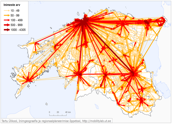
Figure 1. Daily commuting patterns between Estonian municipalities, leading to defining new regional and subregional centers and their areas of influence.
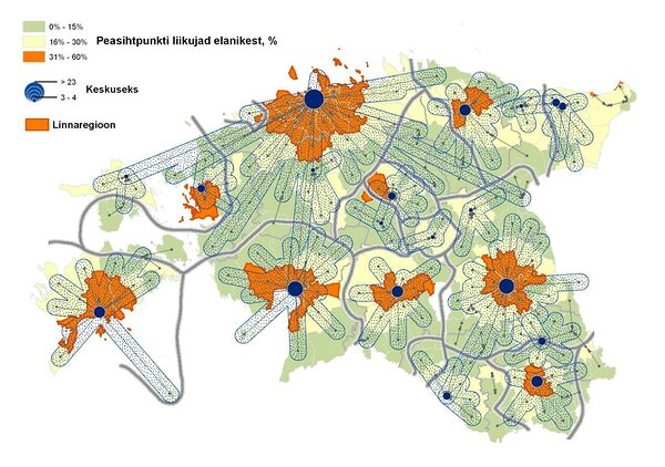
Figure 2. The study revealed 50 towns and cities that act as regional attraction centers (blue bubbles, the size of the bubble indicates the number of municipalities connected, and shaded areas denote the percentage of the nearby municipalities’ residents commuting to the center)
Figure 3. Net commuting destinations (red) and net commuting donors (blue). Every day, cities in Estonia receive a net gain of 10 to 20% of their population from commuters. Every day, there are parishes that lose up to 80% of their day-time population due to commuting.
Figure 4. Seasonality: Shift of home anchors between February and July that provide a strong positive correlation (more than 0.9). During the summer in July, there are places in Estonia that gain more than 2/3 of their population. At the same time, 5 cities in Estonia, including the capital, lose more than 10% of their citizens, as people move to summer homes.
Methodology
Positium analysed CDR and IPDR datasets from one mobile network operator to produce anchor points for people and analysed movements between those points. The observed data period ran from 2007 to 2009 for the first project, and in 2011 for the second, follow-up project.
The anchor point method by Positium enables to calculate home and work-time places, and distinguish movements between those places by the temporal and spatial pattern of the anonymous user. The algorithms to detect home locations and usual environments have been developed through cooperation with the University of Tartu in Estonia. More information about the algorithm can be found in the article “Modelling Home and Work Locations of Population Using Passive Mobile Positioning Data” (Ahas et al, 2009). Statistical methods are used to estimate one operator’s data to the general population.
The University of Tartu used the population census 2000; residential register data and a questionnaire survey by TNS Emor for calibration of the model. The actual locations of individuals were very different from population register data and census data, a problem with registry data in Estonia.
We are thankful to the largest mobile operator in Estonia at the time, EMT/TeliaSonera, who provided the raw data for analysis and is a long-term partner to Positium.
The privacy of the phone owners is strictly protected in this study according to the EU data protection regulations (DIRECTIVE 2002/58/EC). The requirements specified in the EU directives on processing personal data and the protection of privacy in the electronic communications sector were strictly implemented and evaluated by the Estonian Data Protection Inspectorate.
Determining project success in the eyes of the Ministry
The commuting study undertaken in Estonia was the first study of its kind in the world.
It is not possible to achieve statistically relevant survey samples for 213 local municipalities without exorbitant costs. The census, held every 10 years, provides the only viable alternative source of data to study the need for commuting across geography as wide as a country.
The study is a very good source of information for the local decision-makers. It is one of the core inputs to defining the regional attraction centres and for the administrative reform.
Administrative borders should foremost be concerned with how people live their everyday lives and not artificially subjugate people within present administrative borders.
On the other hand, the data collected within the study will impact the development of the regional programmes of the coming years that aim to strengthen local attraction centres and improve means of transport.”
Siim Kiisler, the Minister of Regional Development 2008-2014
While the study’s scope encompassed the entire country, the results were given with enough granularity to be informative at the municipality level.
The results of the study have all been integrated into regional development strategies. The data also informs the discussion on administrative reform in Estonia. Current plans call for a monitoring system to provide automated updates of the results.
Would you be interested in learning more about mobile big data and Positium? Let's talk about what mobile big data can do to help your organisation make decisions based on population mobility.
.png)


%20inimeste%20arvu%20erinevus_block.png)
%20positiivne%20korrelatsioon%20sesoonsuse%20faktoriga_block.png)